
The pursuit of meteorological data has long been a high-stakes endeavor, characterized by armored vehicles and ground-based sensors deployed in the paths of the world’s most violent storms. However, a specialized team of researchers and engineers known as the OTUS Project—Observations of Tornadoes by UAV Systems—is fundamentally altering the landscape of atmospheric science by piloting custom-built Unmanned Aerial Vehicles (UAVs) directly into the heart of active tornadoes. This initiative has successfully achieved more than a dozen intercepts, culminating in a historic June event where the team live-streamed a drone’s penetration into an EF3 tornado, providing a perspective and data set that was previously considered unattainable.
The Arnett Intercept: A Milestone in Meteorological Observation
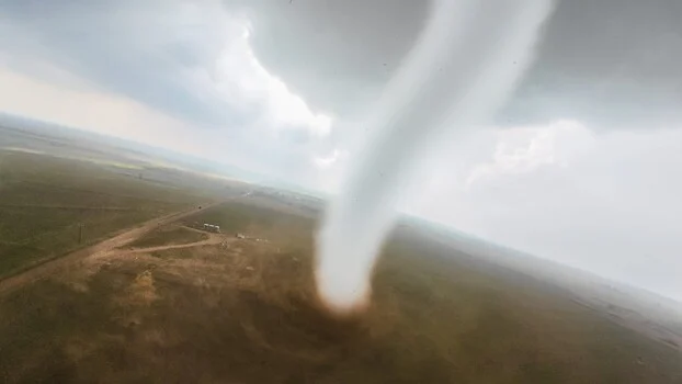
The most striking demonstration of this technology occurred near Arnett, Oklahoma, on May 18, 2025. As a powerful supercell developed over the Southern Plains, the OTUS team deployed their fleet to intercept a developing funnel. The resulting footage, captured by a high-definition camera mounted on a drone flying at extreme speeds, showed the transition from the turbulent inflow jet to the violent, debris-filled core of the vortex. Unlike stationary ground sensors, which are often destroyed or bypassed by the shifting path of a storm, the OTUS drones maintained a controlled flight path, orbiting the funnel at varying altitudes before spiraling inward.
This intercept provided more than just a visual spectacle; it served as a proof of concept for a new era of "in-situ" data collection. By navigating the drone through the vertical wind loads of an EF3 tornado, the team was able to record real-time fluctuations in pressure and temperature that occur within seconds of a vortex passing. For meteorologists, the Arnett intercept represents a breakthrough in understanding the "near-surface" environment—the lowest few hundred feet of the atmosphere where tornadoes do the most damage to human structures, yet where radar coverage is often blocked by the curvature of the earth or physical obstructions.
Engineering Resilience: Why Off-the-Shelf Drones Fail in Extremes
The primary challenge of the OTUS Project was not merely finding a tornado, but building a machine capable of surviving one. Standard consumer drones, even high-end professional models used in cinematography, are designed for stability and efficiency in relatively calm conditions. In the environment of a tornadic supercell, where wind speeds can exceed 100 miles per hour and vertical updrafts can reach 50 miles per hour, a standard drone is effectively a leaf in a gale. The drag produced by a traditional airframe would cause the motors to burn out or the structure to shatter under the stress of debris impacts.
To solve this, the OTUS team turned to bespoke engineering. Louis Tucker, the 2023 National Collegiate Drone Racing champion, serves as the lead pilot and primary builder. His background in high-speed racing provided the foundational knowledge required to manage aircraft at the edge of their physical limits. Working alongside engineer Tanner Beard, the team utilizes a sophisticated home workshop equipped with a mill, a lathe, welders, and a bank of high-end 3D printers.
The resulting aircraft are marvels of power-to-weight optimization. Weighing approximately two pounds, these drones are constructed from 3D-printed materials designed for maximum rigidity and minimal surface area. They are capable of reaching speeds of 220 mph, a velocity that allows them to "punch" through the intense pressure gradients surrounding a tornado’s core rather than being swept away by them. This speed is the drone’s primary defense mechanism; by moving faster than the surrounding air currents, the pilot can maintain directional control even in the face of extreme turbulence.
The Physics of Flight and the NIST Collaboration
The scientific value of the OTUS Project is anchored in its specialized instrumentation. While the visual footage is what captures public attention, the sensors are the heart of the mission. Each drone in the 15-aircraft fleet carries a suite of instruments designed to log temperature, humidity, and barometric pressure. However, the most significant technological leap is the omnidirectional wind sensor.
Traditional anemometers are far too heavy and bulky for a two-pound drone. To address this, Nelson Tucker collaborated with the National Institute of Standards and Technology (NIST) to develop a lightweight, omnidirectional sensor capable of measuring the 3D wind loads of a tornado—specifically the vertical component. In meteorological terms, the vertical wind speed within a tornado is one of the most difficult variables to measure accurately. Ground stations only measure horizontal flow, and mobile Doppler radars can only estimate vertical motion based on the movement of precipitation or debris. By placing a physical sensor inside the updraft, OTUS is providing the first direct measurements of the forces that lift houses and vehicles off the ground.
A Chronology of Innovation and Personal Investment
The evolution of the OTUS Project is a testament to the power of independent research. The project did not begin in a university laboratory but in the field, born from a desire to bridge the gap between hobbyist drone flight and professional atmospheric research.
- 2023: Louis Tucker wins the National Collegiate Drone Racing Championship, refining the piloting skills and airframe designs that would later be adapted for storm chasing.
- Late 2023 – Early 2024: The team begins prototyping airframes that can carry meteorological payloads without sacrificing the speed necessary for storm intercepts. Initial tests involve flying into high-wind thunderstorms to test structural integrity.
- Spring 2024: The first successful "proximity" flights occur, where drones are flown near the outer circulation of weak tornadoes to calibrate sensors.
- June 2024: The project achieves its first major milestone, successfully flying a drone into an EF3 tornado and live-streaming the data to a global audience.
- May 2025: The Arnett, Oklahoma intercept provides the most comprehensive data set to date, including high-definition internal footage and synchronized sensor logs.
The financial burden of this research has been borne almost entirely by the team. With individual drones costing upwards of $2,500 and the high probability of equipment loss during an intercept, the team has invested more than $25,000 of their own money within a single year. This "citizen science" approach allows for a level of risk-taking and rapid iteration that is often impossible within the constraints of government-funded academic grants.
Scientific Objectives: Sharpening the Warning Window
The ultimate goal of the OTUS Project extends beyond the thrill of the chase; it is centered on public safety. Currently, the National Weather Service (NWS) relies on a combination of Doppler radar, satellite imagery, and ground spotters to issue tornado warnings. While effective, this system has limitations. Radar "beams" widen as they travel away from the station, meaning that for a storm 60 miles away, the radar is looking at a point several thousand feet above the ground. What is happening at the surface—where people live—is often an educated guess based on upper-level rotation.
By providing real-time, surface-level data from the core of the storm, the OTUS Project could help meteorologists identify the exact moment a rotation "tightens" and touches down. This data could potentially increase the "lead time" for tornado warnings. Currently, the average lead time is approximately 13 to 15 minutes. If high-speed UAVs can identify the precursors to tornadogenesis within the inflow layer of a storm, those precious minutes could be doubled, giving residents more time to seek underground shelter.
Furthermore, the data regarding 3D wind loads is invaluable for structural engineers. Understanding the precise pressure changes and vertical lifting forces within a vortex allows for the development of better building codes and more resilient storm shelters.
Broader Implications and the Future of UAV Meteorology
The success of the OTUS Project signals a shift in how humanity interacts with extreme weather. We are moving away from a reactive posture—where we observe the aftermath of a storm—toward a proactive, immersive data-gathering model. The ability of a small, $2,500 aircraft to survive conditions that would destroy a multi-million dollar mobile radar truck suggests that the future of storm chasing is small, agile, and unmanned.
As the technology matures, there is potential for "swarm" deployments, where dozens of drones are released into a single supercell to map the entire wind field simultaneously. This would provide a four-dimensional view of a tornado’s lifecycle, from birth to dissipation. For now, the OTUS Project remains a lean, highly specialized operation, pushing the boundaries of what is possible with 3D printing, racing technology, and raw determination.
The imagery captured near Arnett, Oklahoma, stands as a landmark in the history of storm photography, but for the OTUS team, it is merely the beginning. As they continue to refine their sensors and airframes, the "impossible" task of flying into a tornado is becoming a routine, albeit dangerous, day at the office. The data they bring back from the vortex may one day be the key to saving countless lives across the world’s most storm-prone regions.